Itinerary (+2 Days, Entry and Exit)
Planning an extended itinerary, including entry and exit logistics, is a crucial aspect of any travel adventure. Those extra two days can make all the difference in fully experiencing a destination's hidden treasures.
If you're feeling overwhelmed by the details or need assistance in organizing your travel plans, consider seeking help to "write my memo for me." Crafting a comprehensive memo can help streamline your itinerary, ensuring that every moment of your extended stay is well-spent and enjoyable. With a well-structured plan in place, you can make the most of your journey, whether it's for leisure or business.
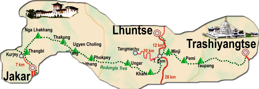
Day 1: Jakar – Ngang Lhakhang (Distance 20km, six to seven hours, camp altitude 2,800m)The route takes you around Chamkhar Chhu, a river rich in trout. After passing Thangbi Lhakhang, a temple built by the first Karma Shamar in 13th century, further ahead you enter Ngang Yul, ‘Swan Land” and at its center is Ngang Lhakhang, the “Swan Temple”. This part of the valley was at first inhabited by swans who gave their name (Ngang) to the place. The Lama Namkha Samdrup, having dreamt a vision of how to build a temple, shot an arrow and at the spot where the arrow landed, the Ngang Lhakhang was erected. Day 2: Ngang Lhakhang – Ugyenchholing (Camp altitude 2,850m) Climb gradually to Phephe La pass (3,353m). Follow the trail until the pass takes you through one of the most stunning forested areas of this region. Allow for stops to enjoy the natural beauty of the surroundings. Ugyen Choling Palace houses one of the most interesting museums of Bhutan. Day 3: Ugyen Choling – Phokphey (Distance 17km, five to six hours, 920m ascent, camp altitude 3,680m) Today’s walk is through bamboos, hemlock and finally up to an alpine forest. The camp is in a meadow at the head of the valley. Day 4: Phokphey – Pemi (Distance 20km, six to seven hours, 480m ascent, 1,160m descent, camp altitude 2,950m) Rodung La (4,160m) is about three hours climb from the camp. From the pass you then continue downhill through a gorge, overlooking some of the mountain valleys. The region is well known for its sightings of ghosts and yetis. Towards the camp you see pine trees and the ruined stone building was the grain storehouse during the times of the first and second king. Day 5: Pemi – Khaine Lakhang (Distance 21km, seven to eight hours, 350m ascent, 1,340m descent, camp altitude 2,010m) This trail winds up and down, passing the villages of Ungaar, Bulay, Kulaypang and Gomda till you reach Drula village and Khaine Lhakhang en route. It is one of the oldest temples in existence today, built in mid 7th century by the King Songtshen Gampo of Tibet to subdue demons. Day 6: Khaine Lakhang – Tangmachu (Distance 18km, six to seven hours, 520m ascent, 810m descent, camp altitude 1,720m) From your camp, the trail goes down to a stream and back up to a basic health unit and community school in Gorsam. Further on, you pass a Tibetan-style Umling Mani, built by a lama from Tibet, and a chorten on Zerim La (1,940m). Before reaching the next pass, Tage La (1,760m) you will see Menjabi, a beautiful Bhutanese village with large white houses. South-east of Tage La is Tangmachu High School. About 400 students study in this school. There is a campsite near the school. Another possibility is to organise transport and drive to Lhuentse, the capital of Lhuentse district, with its impressive dzong. Day 7: Tangmachu – Menji (Distance 16km, four to five hours, 690m ascent, 620m descent, camp altitude 1,830m) Arrive firstly to Kuri Zampa and the trek from here is gradually up through the paddy fields and villages to Chusa. Day 8: Menji – Pemi (Distance 20km, five to six hours, 620m ascent, camp altitude 2,450m) Continue uphill through thick forests overlooking mountain views. The camp is under forest shelter at an altitude of 2,400m. Distance: 20 km. Time: six to seven hours. Day 9: Pemi – Taupang (Distance 21km, seven to eight hours, 1,450m ascent, 1,450m descent, camp altitude 2,450m) Continue up to Dongla where you will have fascinating mountain views. Descend through thick evergreen forests till you reach campsite. Overnight campsite. Distance: 21 km. Time: six to seven hours. Day 10: Taupang – Trashi Yangtse (Distance 24km, eight to nine hours, 720m descent) Today is the longest trek. It is a gradual downhill trek till Yangtse through chir pine and hardwood forests, and then oak in the sub tropical forest zone. Overnight camp. Distance: 24 km. Time: eight to nine hours. |
Ancient Trade Route
This route was the most important trade route to Eastern Bhutan til the road was built. Nowadays hardly anybody, except some ardent trekkers, travels along this route. The route can also be seen as an extension of the Snowman Trek ending in Bumthang. The combination of the two of them, Snowman and Rodung La trek, connects the country from the West (Paro) to the far East (Trashi Yangtse). Although the trek does not lead into really high altitude, it is tough and involves long steep descents or ascents, depending on the side you start the trek. Definitely one of the harder treks in Bhutan!
Fare Breakdown
|
 |
|